Yesterday I drove to Unicoi State Park, just north of Helen, GA, for a hike on the Appalachian Trail (AT) from Unicoi Gap toward Tray Mountain.
That section of the AT doesn't go through the part of the park we were in. Oops.
A quick carpool 10 miles up the road we found the trail at Unicoi Gap. Up the trail we head. Its 6.2 miles (one way) to Tray Mountain, but we were not planning on going the entire distance. We broke up the team into 2 groups, those who wanted to hike 3 hours and those wanting to hike 4.5 hours. Each team left the same time and was instructed to turn around after half of their time had elapsed (i.e. 1.5 hours out).

I was sweeping — in the back of the pack to make sure everyone was OK — for the longer group, so I started up the trail at the back of the pack with Sandy and her dog Eva. The first climb was from Unicoi Gap to Rocky Mountain, an elevation change of over 1000' in 1.3 miles. This was an unrelenting climb all the way to the top! After stopping and grabbing some pictures I headed down again and met up with the 3 and 4.5 hour groups at Indian Grave Gap where everyone was having a bite to eat. The 4.5 hour group headed off about 10 minutes ahead of me, giving me some great time alone on the trail. It was a beautiful, but cold, day and I was enjoying a little solitary hiking.
And then it happened. Sandy had passed all the members on the shorter hike and decided she better catch up to the rest of us. I have no idea how she did it, but she ran right up behind me. I picked up the pace and we hiked out to just before the trail climbs to Tray Gap. The group had assembled there to take in the view of Tray Mountain and the surrounding area from a beautiful rock outcropping.
 After some pictures, we turned back to Indian Grave Gap and started back up to the top of Rocky Mountain...
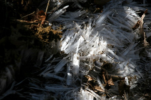
The legs were willing, the lungs were not. It was a long, hard hike for me and another hiker ,who was also having trouble breathing, as we came up to the ridge a few minutes behind the rest of the pack. Thankfully its downhill all the way back to the cars, I don't think I could have taken on another long, steep trail! By now the ice on the trail had melted, making the descent muddy, so I was happy to get back to the trail head, back to my car and out of my hiking boots.
Overall we hiked ~8.4 miles in a little more than 4 hours.
 One question remains: Can someone explain how ice forms like this? I swear it looks like fiberglass fibers strewn on the ground.
No comments:
Post a Comment